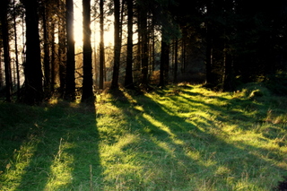
Walking in the Rosenallis Area
 The
location of Rosenallis makes it the ideal place to start exploring
the Slieve Blooms. There are many varied walks that will suit the
beginner and veteran walker alike from the lofty windswept moorlands
to relaxing riverside forest walks.
The
location of Rosenallis makes it the ideal place to start exploring
the Slieve Blooms. There are many varied walks that will suit the
beginner and veteran walker alike from the lofty windswept moorlands
to relaxing riverside forest walks.
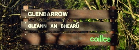
Glenbarrow in Rosenallis marks the official starting and finishing
point of the Slieve Bloom Way, an 80Km circuit of the mountain range
and part of the National Waymarked Ways of Ireland. Recently
upgraded (2007), The route takes the walker past deep glens, rocky
outcrops, waterfalls and lofty summits which are said to have a
brooding personality of their own. Glenbarrow itself boasts a
beautiful walk along the banks of the River Barrow to the well known
three tier waterfall known locally as the "Clamp Hole Falls".
If you like panoramic views of the surrounding countryside then the
Ridge of Capard is not to be missed. At almost 500m above the
surrounding flat countryside, the wild windswept ridge is home to a
vast array of wild plant and animal life and it is possible to see
well into the counties surrounding Laois. On a clear day the Wicklow
Mountains are visible to the east. Also on the ridge is an ancient
stone cairn known locally as 'The Stony Man" which was built during
the time that quarrying was carried out in the area.
Close by the Ridge of Capard is the old ruined village of Cone. Once
home to fifteen families and self sufficient with it's own mill on
the River Barrow, the last family left the area in the 1960s. While
the area has since been planted with trees, the remains of the
houses and boundary walls are still intact.
To reach Glenbarrow, take the minor road near the red-brick
catholic church uphill out of the village. Then take the next road
to the right and finally the next road to the left. The route is
well marked with white on brown signposts. The National Grid
Reference is N 367 82 and the area is
covered by sheet 54 of the Ordnance Survey Ireland Discovery Series
maps.